
image: There has long been a debate in the scientific community about whether Mars had an ocean in its low-lying northern hemisphere. Using topographic data, a Penn State-led research team was able to show definitive evidence of an approximately 3.5 billion year old coastline with substantial sedimentary accumulation, at least 900 meters thick, which covered hundreds of thousands of square kilometers.
see After
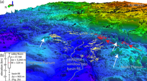
Credit: Benjamin Cardenas/Penn State
A recently released set of topographic maps provides new evidence for an ancient northern ocean on Mars. The maps offer the strongest case yet that the planet once experienced sea level rise consistent with a prolonged hot and humid climate, and not the harsh, frozen landscape that exists today.
“What immediately comes to mind as one of the most important points here is that the existence of an ocean of this size means a higher potential for life,” said Benjamin Cardenas, assistant professor of Geosciences at Penn State and lead author of the recently published study. in the Journal of Geophysical Research: Planets. “It also tells us about the ancient climate and its evolution. Based on these findings, we know that there must have been a time when it was warm enough and the atmosphere was thick enough to support so much liquid water at once.
There has long been a debate in the scientific community about whether Mars had an ocean in its northern hemisphere at low altitude, Cardenas explained. Using topographic data, the research team was able to show definitive evidence of an approximately 3.5 billion year old coastline with substantial sedimentary accumulation, at least 900 meters thick, which covered hundreds of thousands of square kilometres.
“The big novelty we did in this paper was thinking about Mars in terms of stratigraphy and sedimentary record,” Cardenas said. “On Earth, we trace the history of waterways by examining the sediments that are deposited over time. We call it stratigraphy, the idea that water carries sediment, and you can measure changes on Earth by understanding how sediment accumulates. That’s what we did here, but it’s Mars.
The team used software developed by the United States Geological Survey to map data from the National Aeronautics and Space Administration (NASA) and the Mars Orbiter laser altimeter. They discovered more than 6,500 kilometers of river ridges and grouped them into 20 systems to show that the ridges are likely eroded river deltas or undersea channel belts, remnants of an ancient Martian coastline.
Elements of the rock formations, such as the thicknesses of the ridge system, elevations, locations and possible directions of sediment flows helped the team understand the evolution of the region’s paleogeography. The area that was once ocean is now known as Aeolis Dorsa and contains the densest collection of river ridges on the planet, Cardenas explained.
“The rocks of Aeolis Dorsa capture fascinating information about the state of the ocean,” he said. “It was dynamic. The sea level has risen considerably. Rocks were being deposited along its basins at a rapid rate. There have been a lot of changes here. »
Cardenas explained that on Earth, ancient sedimentary basins contain the stratigraphic records of the evolution of climate and life. If scientists want to find a record of life on Mars, an ocean as large as the one that once covered Aeolis Dorsa would be the most logical place to start.
“One of the primary goals of the Mars Curiosity rover missions is to search for signs of life,” Cardenas said. “He always looked for water, traces of habitable life. It’s the biggest to date. It is a giant body of water, fed by sediments from the highlands, presumably carrying nutrients. If there had been tides on ancient Mars, they would have been here, gently bringing in and leaving water. This is exactly the type of place where ancient Martian life could have evolved.
Cardenas and his colleagues mapped what they determined to be other ancient waterways on Mars. A forthcoming study in the Journal of Sedimentary Research shows that various outcrops visited by the Curiosity rover were likely sedimentary strata of ancient river bars. Another paper published in Nature Geoscience applies an acoustic imaging technique used to visualize the stratigraphy beneath the Gulf of Mexico seafloor to a Mars-like basin erosion model. The researchers determined that landforms called river ridges, found widely on Mars, are likely ancient river deposits eroded from large basins similar to Aeolis Dorsa.
“The stratigraphy that we interpret here is quite similar to the stratigraphy on Earth,” Cardenas said. “Yes, it sounds like a big pretentiousness to say that we have discovered records of major waterways on Mars, but in reality it is relatively mundane stratigraphy. It’s textbook geology once you recognize it for what it is. The interesting part, of course, is that it’s on Mars.
The other co-author of the JGR: Planets paper is Michael P. Lamb, professor of geology at Caltech. The work was funded by the National Aeronautics and Space Administration (NASA).
Log
Journal of Geophysical Research Planets
Research method
Data/statistical analysis
Research subject
Not applicable
The title of the article
Paleogeographic reconstructions of an oceanic margin on Mars based on deltaic sedimentology at Aeolis Dorsa
Publication date of articles
12-Oct-2022
Disclaimer: AAAS and EurekAlert! are not responsible for the accuracy of press releases posted on EurekAlert! by contributing institutions or for the use of any information through the EurekAlert system.
#Traces #ancient #oceans #Mars