You’re no doubt familiar with the dry, dusty look of Mars as it looks today – but scientists have found evidence of a vast ocean existing on the Red Planet’s surface around 3.5 billion years ago. years, probably covering hundreds of thousands of squares. kilometers.
This evidence comes in the form of distinctive coastline topography, identified by numerous satellite images of the Martian surface. When these images are captured at slightly different angles, a relief map can be constructed.
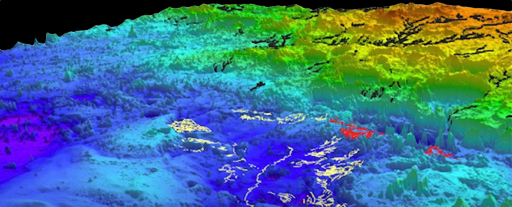
Researchers were able to map more than 6,500 kilometers (4,039 miles) of river ridges, apparently carved out by rivers, demonstrating that they are most likely eroded river deltas or submarine channel belts (channels carved into the seabed).

“The big novelty we did in this paper was thinking about Mars in terms of stratigraphy and sedimentary record,” says geoscientist Benjamin Cardenas of Pennsylvania State University.
“On Earth, we trace the history of waterways by looking at the sediments that are deposited over time. We call this stratigraphy, the idea that water carries sediment, and you can measure changes on Earth by understanding the way sediment accumulates. That’s what we’ve done here – but this is Mars.”
Using Mars Reconnaissance Orbiter data collected in 2007, the team applied analysis of ridge thicknesses, angles, and locations to understand the study area: the topographic depression known as the Aeolis Dorsa region. on Mars.
It seems likely that a significant amount of change was happening to this part of the planet all those years ago, Cardenas says. This is demonstrated by the evidence of substantial sea level rises and the rapid movement of rocks by rivers and currents. Today, Aeolis Dorsa contains the most concentrated collection of river ridges on Mars.
This is all related to the search for life on Mars. One of the most fundamental questions scientists ask about the Red Planet is whether it ever had conditions hospitable enough to support life.
“What immediately comes to mind as one of the most important points here is that the existence of an ocean of this size means a higher potential for life,” says Cardenas.
“It also tells us about the ancient climate and how it evolved. Based on these findings, we know that there must have been a time when it was warm enough and the atmosphere was thick enough to support so much liquid water at a time.”
Researchers do not stop at the Aeolis Dorsa region.
In a separate study published in nature geosciencesome of the same researchers, including Cardenas, have applied an acoustic imaging technique used to map the ancient seabed of the Gulf of Mexico to a model of how water may have eroded the surface of Mars.
There are large areas of what could be river ridges on Mars, and the team’s simulations are remarkably similar to the shape of the landscape on the Red Planet, suggesting there was water cover. extended at any given time.
We’re seeing more and more signs that water was once plentiful on Mars, and work continues to determine what this might have led to and where that water is now – although looking back billions of years is not easy.
“If there had been tides on ancient Mars, they would have been here, gently bringing in and leaving water,” says Cardenas. “This is exactly the type of place where ancient Martian life could have evolved.”
The research has been published in Journal of Geophysical Research: Planets and nature geoscience.
#Ancient #traces #giant #ocean #discovered #Mars